Participatory 3-Dimensional Modelling: Guiding Principles and Applications
Introduction
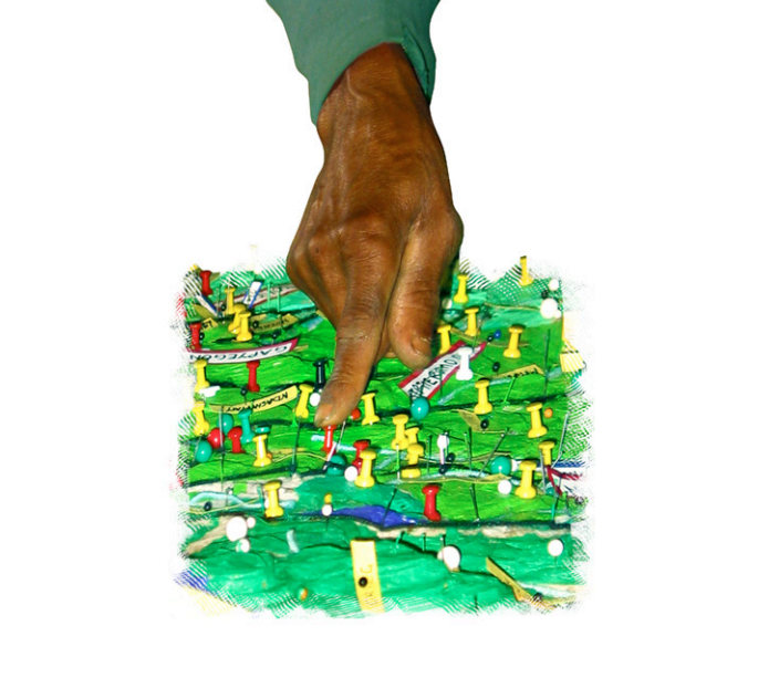
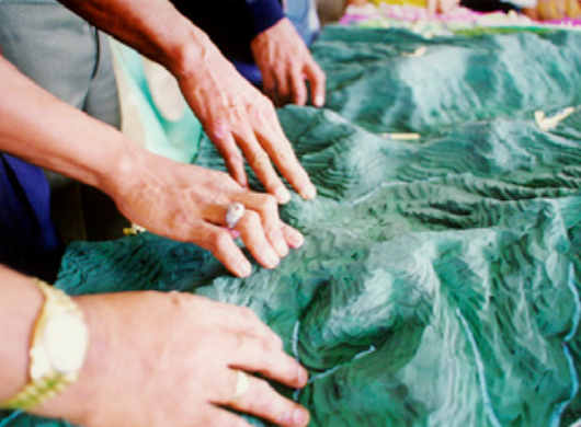
Participatory three-dimensional modelling (P3DM) is a participatory mapping method integrating indigenous spatial knowledge with data on elevation of the land and depth of the sea to produce stand-alone, scaled and geo-referenced 3D models. Essentially based on recollections from memory, land use and cover and other features are depicted by informants on the model by using push pins for points, yarns for lines and paints for polygons. On completion, a scaled and geo-referenced grid is applied to facilitate data extraction or importation. Data depicted on the model are extracted, digitised and plotted. On completion of the mapping exercise, the model remains with the community.
P3DM has been conceived as a method for bringing the potential of Geographical Information Systems (GIS) closer to rural communities and for bridging the gap that exists between geographic information technologies and capacities found among marginalised and isolated communities who are frequently dependent on natural resources.
This handbook* is intended to assist activists, researchers and practitioners of participatory learning and action (PLA) and GIS to bring the power of GIS to the grassroots level through the use of P3DM. It provides comprehensive, hands-on guidelines on how to organise and implement a P3DM exercise. In addition it includes insights on adult learning and spatial cognition, on the history of relief models and on the use of the method around the world.
*download available from right-hand column or via links below (including versions in French, Spanish, Amharic and Portuguese).
A Step-by-Step guide to P3DM
[video: https://vimeo.com/30723012]P3DM is a process that can be used to generate a series of physical outputs, the information from which may be stored in a database for use in a GIS. The basic steps (which are covered in detail in the handbook) in producing a 3D model and derived maps are as follows:
- Conducting preparatory work
- Assembling the blank model
- Preparing the map legend
- Depicting information
- Handing over the model
- Extracting data
- Digitising and manipulating data
- Cross-checking and validating
The P3DM’s main function is to generate, through a participatory process, spatially defined, georeferenced and scaled data. This is not the case with most sketch mapping techniques. The P3DM process requires thorough preparation in procuring supplies, discipline in adhering to colour coding and precision in conducting all steps.
Cross-cutting Functionalities of Participatory 3D Modelling (abridged)
Twenty years of experience in developing countries has shown that 3D models – which are used independently or which are integrated with GIS and GPS and made part of broader action-oriented processes – contribute to a number of basic functionalities in human development and interaction. These include:
Discovery learning:P3DM is tailored for areas where poverty, isolation, marginalisation, low literacy and language barriers frequently shape society. The tendency for most people residing in these areas is to learn by concrete sensorial experiences, rather than by abstract concepts. Therefore, it has been seen that villagers – when properly oriented – can manage the P3DM process with ease and great enthusiasm, progressing through the various stages of learning. In fact, the physical nature of the method enhances discovery learning through verbal, visual and tactile experiences, stimulates feedback, promotes debate and negotiation and generates shared information in visible and tangible formats.
Visualising knowledge:This method, through an intensive learning process, increases the awareness that P3DM participants have about their knowledge. This augments participants’ capacities to analyse, communicate and interact on specific issues.
Participatory legend making and visual language:A legend, if made correctly, puts the knowledge-holders in the driver’s seat. It allows them to express a complex network of ideas, concepts and interlocking criteria that will be visualised and coded on the model. A well-prepared legend clarifies meanings and maps out the relationships between natural and cultural features. The P3DM process allows participants to document and locate their tangible and intangible heritage and show cultural sites, knowledge systems and important physical sites.
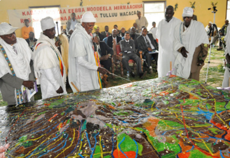
Intra- and intergenerational knowledge exchange: The P3DM process helps reclaim lost memories about the traditional ways of living. In the presence of elders and youth, it facilitates intergenerational knowledge exchange and raises awareness across generations about the status of the environment. In many instances, participants conclude that they gain a more holistic understanding of their social, cultural and biophysical environments, and that they realise the importance of working together towards a common goal. They also become aware of the value and potential authority of their spatial knowledge after it is collated, georeferenced, documented and visualised.
Supporting community cohesion and self-determination:Manufacturing a 3D model has positive effects in stimulating community cohesion because it gathers people to share information and concerns and frequently reinforces community self-actualisation through the revival of local knowledge. A well-displayed 3D model is appealing, fuels community esteem and a sense of intellectual ownership and becomes part of the local cultural landscape. Villagers frequently use these models to introduce visitors to the area – a simple act that signifies peer-topeer information sharing and calls for silent acknowledgment of the existence of local knowledge.
Improving communication:In providing open access to information, 3D models add transparency and create common ground for discussion. They broaden individual perspectives and limit the distortion of messages between communicating parties by offering a shared language of colours, shapes and dimensions. In doing this, 3D models bridge language barriers and ease communication on issues bound to the territory and its resources. This is particularly relevant for people with different education levels, cultural backgrounds and diverse or conflicting interests.
Bridging isolation and supporting change and innovation: To reach central institutions, information displayed on 3D models has to be portable and widely shareable. This is made possible by fully integrating P3DM with a GIS, which allows for the conversion of the data depicted on models into a mobile and reproducible cartographic format. In turn, a GIS can generate data sets, which can be entered onto the 3D model to enrich the learning and negotiation process. If adequate linkages and networks are established, and depending on the existing regulatory framework, innovations supported by P3DM outputs (e.g. models, maps, plans) and advocacy campaigns can reach higher institutional levels and may influence national policy making.
Scaling the territory: By miniaturising (i.e. 1:5,000–1:20,000) real world features as they are known and perceived by participants, P3DM has proven to be particularly effective in dealing with relatively large and remote areas and in overcoming logistical and practical constraints to public participation in land- and resource-use planning and management.
The P3DM process was fine-tuned and disseminated by a network of practitioners nurtured by Giacomo Rambaldi, currently working for CTA.
This handbook was published by the Technical Centre for Agricultural and Rural Cooperation ACP-EU (CTA), in July 2010.
ISBN: 978-92-9081-448-1
Suggested citation:
Rambaldi, Giacomo. 2010. Participatory Three-dimensional Modelling: Guiding Principles and Applications, 2010 edition. CTA, Wageningen, the Netherlands.
Training Materials:
- Read/download the handbook in English
- Read/download the handbook in French
- Read/download the handbook in Spanish
- Read/download the handbook in Amharic
- Read/download the handbook in Portuguese
- Training Kit on Participatory Spatial Information Management and Communication
- Practical ethics for PGIS practitioners, facilitators, technology intermediaries and researchers
Online reference sites:
- Participatory Geographic Information Systems [CTA]: pgis.cta.int
- Participatory Avenues (IAPAD): www.iapad.org
Related resources
- View the P3DM handbook on the IAPAD website
- See where P3DM has been used around the world
- P3DM wins the World Summit Award 2007
- Participatory 3D Modelling (P3DM): five years after receiving the World Summit Award [video stories!]
- Go to the Participatory GIS video channel on vimeo
- "Giving Voice to the Unspoken" - the hands-on aspects of Participatory 3D Modelling [Video]
(0) Comments
There is no content