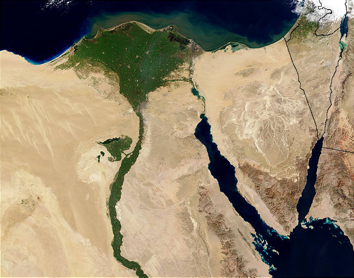
All articles for the topic: climate projections

Blue sky with green mountains covered in colourful looking houses

Human populations in the world’s mountains: Spatio-temporal patterns and potential controls

Delve into the data and trends of human populations in mountainous regions, and explore the associations between mountain populations and different environmental covariates. Findings may inform predictions of future mountain population distributions under scenarios of future climatic change.

Read more
Mountain with a snowy peak and a pink cloud sky

IPCC WGII Sixth Assessment Report Cross-Chapter Paper 5: Mountains

Explore the new evidence on observed and projected climate change impacts in mountain regions, their associated key risks and adaptation measures in this IPCC cross-chapter paper on mountains.

Read more
the globe in light red next to our possible climate futures

IPCC WG1 Interactive Atlas

Explore observed and projected climate change information in this novel tool developed by the UN IPCC. Use the regional information component to generate global climate maps, and the regional synthesis tab to get qualitative information about changes in climatic impact-drivers.

Read more
adaptation learning network logo

Climate Modelling and Forest Adaptation online course

This online course introduces climatic and ecological modelling tools and practical applications of models in forest and ecological resource management. See learning resources and taster videos!

Read more
A village in Kenya

Enabling Climate Science Use to Better Support Resilience and Adaptation Practice

This report reviews the use of climate science in adaptation and resilience practice. It was commissioned by the UK government to inform the development of a new programme. 

Read more
NOAA_unsplash https://unsplash.com/photos/IaRgDQiF36Q

Step-by-step guide: Using climate information to support adaptation planning and policy-making

Guidance on how to quickly and easily access climate data for many locations across Africa, using an interactive map.

Read more
CLIMAP portal

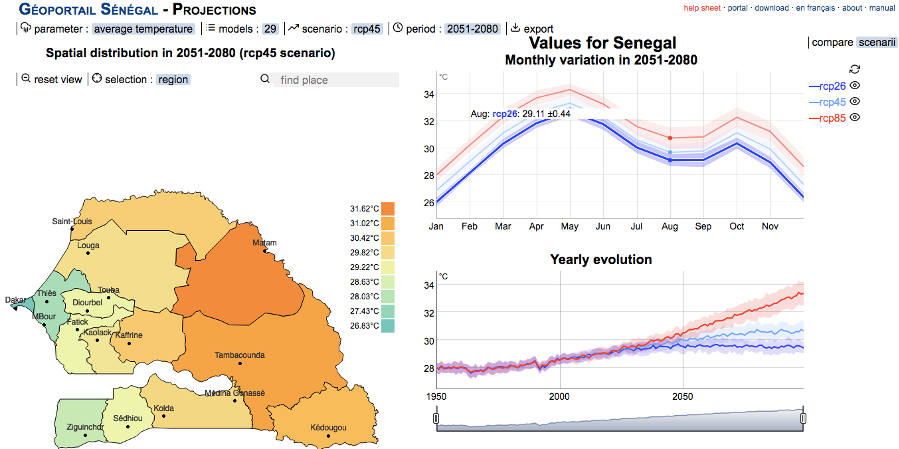
CLIMAP portal: online climate tool to support Senegalese agricultural planning

A new online climate tool, the CLIMAP portal, has been developed to help support agricultural planning in Senegal. 

Read more
Figure 1: Map of all ASSAR study countries.

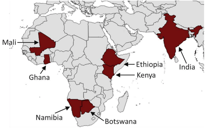
Determining what global warming of 1.5°C and higher means

This article describes ASSAR's method for what global warming of 1.5°C and higher means for the semi-arid regions of Botswana, Namibia, Ghana, Mali, Kenya and Ethiopia.

Read more
climate change scenarios primer

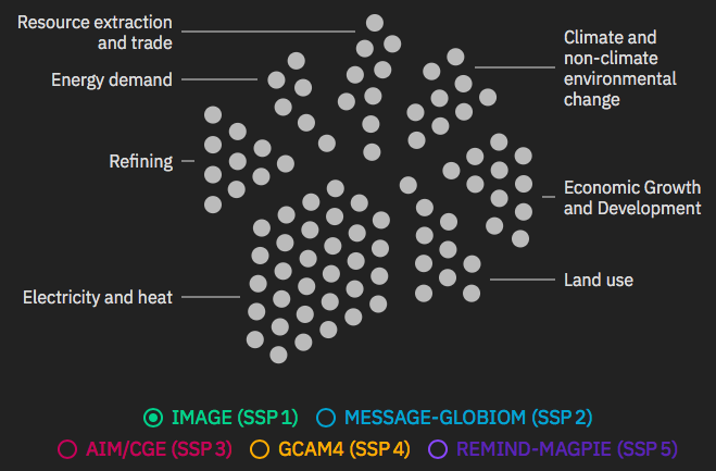
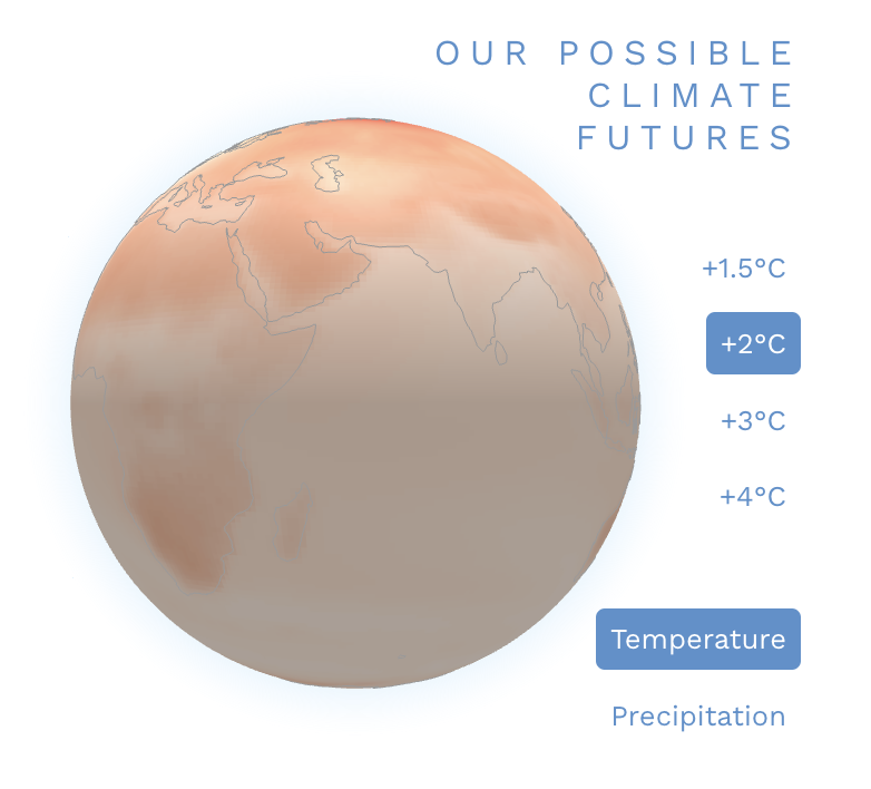
Climate Change Scenario Primer

This interactive primer explains what climate change scenarios are and how they are connected to socioeconomics, energy and land use, emissions, climate change and climate impacts.

Read more
THUNDERSTORM OVER AFRICA

Climate Risk and Vulnerability: A Handbook for Southern Africa (2nd Edition)

An updated version of the popular handbook outlining projected climate change, sectoral impacts and responses (adaptation, disaster risk reduction, and accessing climate finance) in southern Africa

Read more
malawi climate change

Future Climate Projections for Malawi

This brief provides an overview of future climate change in Malawi, using results from the latest available climate model simulations based on 34 global climate models (CMIP-5) used by the IPCC.

Read more
climate projections for tanzania

Future Climate Projections for Tanzania

This brief provides an overview of future climate change in Tanzania, using results from the latest available climate model simulations based on 34 global climate models (CMIP-5) used by the IPCC.

Read more
caribbean weather

Climate data and projections: supporting evidence-based decision-making in the Caribbean

This report provides an overview of climate data and information available from the CARibbean Weather Impacts Group (CARIWIG) data portal and how they can be used to support decision-making.

Read more
PCC

Prairie Climate Centre

The Prairie Climate Centre is a collaboration of the University of Winnipeg and the Internati

Read more
FCFA project logo

IMPALA: Improving Model Processes For African Climate

The project aims to improve the ability of climate models to capture African climate systems, and thereby better enable decision-makers in Africa to use climate information.

Read more
Floods in Guelmim, Morocco in March 2013 (Credit: jbdodane; https://www.flickr.com/photos/jbdodane/).

The climate change, migration and economic development nexus in North Africa

This article addresses the climate change and migration nexus from the perspective of disaster risks and employment, and focuses on Morocco, Tunisia and Egypt.

Read more
Floods in Rbat, Souss-Massa-Draa, Morocco in 2010 (Credit: Mhobl; https://www.flickr.com/photos/87106931@N00/)

Migration, development and climate change in North Africa

This paper looks at the current state of migration in Egypt, Morocco and Tunisia, the risks, opportunities and strategies migration offers, and its nexus with development and climate change.

Read more
54cf6f24c7c57screen-shot-2015-02-02-at-12 - climate adaptation.

FCFA Pilot: Rwanda

FCFA Rwanda Pilot Study: Summary

The Rwanda FCFA case study was undertaken by the Global Climate Adaptation Partnerships (GCAP), working with the UK Met Office and Atkins. The case...

Read more
Using climate information for supporting cacao plantation

Using climate information for supporting cacao plantation over Gorontalo region

Cacao is a shade-loving plant tropical plant found in tropical forests. Cacao grows well under different production systems such as mono-crop, inter-cropping and agro-forestry.

Read more
536cf8bd91bb0wyspa-mahe-seszele - climate adaptation.

Impacts of sea-level rise in Africa

Mahe Island, Seychelles: Image: © zszywka.pl

Impacts of sea-level rise in Seychelles

The Seychelles consist of over 100 islands of granitic and coralline origin...

Read more
536cf3517ff90senegal-coast - climate adaptation.

Impacts of sea-level rise in Africa

Coast of Senegal, south of Saint-Louis. Image: ©panoramio.com

Impacts of sea-level rise in Senegal

Senegal has a coast of 2,065km comprising sandy, deltaic (the...

Read more
536cf048656fflagos-land-expansion - climate adaptation.

Impacts of sea-level rise in Africa

View of Lagos. Image ©http://coastalcare.org/

Impacts of sea-level rise in Nigeria

Nigeria’s coast is 850km long and comprises (from west to east) a barrier-lagoon...

Read more
536cec7040cc6atlantic-morocco - climate adaptation.

Impacts of sea-level rise in Africa

Atlantic coast in Morocco. Image: © kerdowney.com/

Impact of sea level rise in Morocco

Morocco’s 3,500km coast crosses temperate, semi-arid and desert climatic zones...

Read more
536ce69072869503e3ae214281african-coast 1 - climate adaptation.

Impacts of sea-level rise in Africa

Summary

Africa has a large and growing coastal population, including a number of important coastal cities. With sea-level rise, flooding and inundation of coastal areas would be expected...

Read more

Pages

Subscribe to RSS - climate projections