INSIDE STORY: Climate change and flood risk – Challenges for Jamaican towns and communities
Introduction
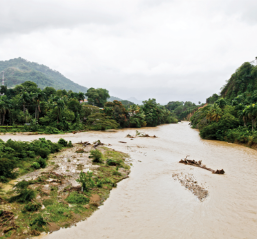
Climate variability in the Caribbean may cause more intense (although perhaps not more frequent) tropical storms and hurricanes in the future. These intense storms with heavy rainfall can result in floods that inundate coastal lowlands affecting tourism, agriculture and major infrastructure. Although maps showing potential flood areas exist for the major watersheds in Jamaica, they do not take climate change into account.
To properly assess future flood risk, rainfall projections using computer climate models should be used to incorporate climate change impacts into risk assessments. The challenge faced by disaster-management authorities, planning agencies and researchers is how best to use the results from the climate models to predict future flood risks for vulnerable communities.
These ideas led to the CDKN-supported project “Climate Change and Inland Flooding in Jamaica: Risk and Adaptation Measures for Vulnerable Communities”, which aimed to address the potential medium- and long-term impacts of climate variability and change on flood risk for selected study areas in Jamaica.
This ‘Inside Story on Climate Compatible Development’* provides an overview of what the project achieved and what team members learned from the experience, and how these lessons could inform other developing country watersheds at risk from climate impacts.
*This Inside Story is summarised below. Please see the full text (dowlowd from the right-hand column) for much more detail.
Barriers
Scaling-down knowledge: The study was able to obtain daily projections of rainfall for a grid with a horizontal resolution of 50 km. However, this covers the entire watershed and does not provide climate data at the sub-watershed level or for the community where actual flooding occurs. Current hydro-meteorological data at sub-watershed and community levels are lacking because there are not enough rain and flood gauges, and data (flood levels, rainfall) are also lost from gauges damaged during intense storms. Incomplete data from specific events prevent detailed and accurate estimation of flood levels for the communities affected.
High-quality topographical data:The accuracy of flood risk predictions will improve if more accurate topographical data for the terrain can be obtained. Even small changes in elevation, of less than 1 m, can be critical for modelling precisely which areas will be inundated and determining which communities, homes, roads and buildings may be affected.
A need for increased capacity at national and subnational levels: Important data for disaster risk management are often not available in digital form or at the scale required to support planning decisions, or sometimes exist in file formats that are not useful. In many countries there are few working rain or wind gauges except at airports, so collecting rainfall data is a problem. While the availability of data is a limiting factor in estimating flood risk in many Small Island Developing States of the Caribbean, local authorities also face constraints in using data. For example, few parish councils in Jamaica can attract and keep persons trained in the use of geospatial data and computing. Although the project was able to train some personnel at the appropriate level of governance, this kind of intervention needs to be continuous, as staff move on and their replacements need to be trained.
A need for post-project sustainability: Often projects are time-bound, and lack of post-project sustainability due to funding issues can present a challenge for continuing with data collection and improving data quality.
Methods and Tools
The key objectives of the project were to:
- Provide a historical overview of the frequency and severity of flooding in Jamaica, and use climatic and non-climatic data to create an island-wide riverine flood hazard map.
- Assess and increase local knowledge, attitudes and practices of project communities regarding climate change through meetings and training.
- Create models for past and future flood events for the selected watersheds.
- Disseminate the results through community and stakeholder training workshops and radio interviews, and via open-access web portals for government and non-government stakeholders and private sector organizations to provide data for mainstreaming climate change in disaster- management strategies.
The project results will also assist Caribbean islands to achieve Sustainable Development Goals (SDGs) 13, 11 and 9.
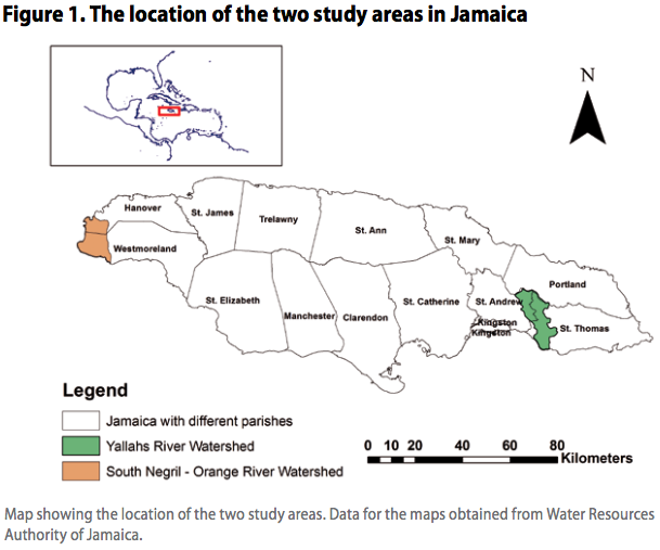
Study Areas:
The project focused on two contrasting watersheds in Jamaica (Figure 1).
- Yallahs, in eastern Jamaica, which is a steep, mountainous river catchment, largely rural in the upper section and urbanised in the lower section.
-
The South Negril–Orange River situated in western Jamaica, an important area for tourism with much of the 8 km shoreline of Negril Bay comprising tourism infrastructure.
Engaging national and local stakeholders on the results
Community meetings were conducted in both Yallahs River (by Jamaica Conservation and Development Trust [JCDT]) and South Negril–Orange River watersheds at three-month intervals for the 18 months of the project with an average attendance of 30 members in each meeting. Those organised and delivered by representatives from the JCDT and project lead involved distribution of fliers on climate change and flooding in Jamaica, followed by presentation of results. In addition, information was broadcast via different radio channels both before and after major newscasts.
A three-day stakeholder workshop was conducted at the end of the project at the Department of Geography and Geology, UWI Mona Campus, Jamaica (May 2014), involving interactive exercises on climate information for Jamaica, dissemination of project results, and a day-long training session on the flood models and the use of the open-source data portal CARISKA. The workshop was a useful platform for sharing knowledge and information from both sides. Questions, ideas and insights from the various stakeholders during this meeting were used to refine the models developed by the project.
Future funding will support the training of stakeholder and community disaster coordinators in use of the Open Data Kit (ODK) App13 for data collection (flood data, damage data), followed by data analysis and uploading on CARISKA.
Outcomes and Impacts
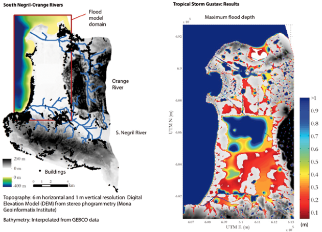
Model results showed flood depth of up to 4 m along the river channel and approximately 2 m downstream for the urban areas for the Yallahs watershed from tropical storm Gustav in August 2008. In the South Negril–Orange River watershed almost all the major infrastructure – hotels, restaurants and craft markets – is located along the coastal section of the watershed, which is impacted by storm surges from tropical storms and hurricanes. In the study, flooding from tropical storm Gustav showed maximum flood depths ranging from 0.5–1 m from inland to coastal areas as a result of rainfall and storm surges.
Future climate projections showed little change in rainfall-induced flood risk, with a moderate decline in risk inland due to reduced rainfall levels. The main area of impact was along the coast, with a larger number of buildings at risk in the future due to rising sea level.
Lessons Learnt
Experience from the project shows:
- Flood hazard maps showing present and future flood risk for vulnerable communities at national and subnational levels are vital for disaster management and for planning climate compatible development in flood-prone areas.
- Local government staff including disaster coordinators at parish level and community representatives should be offered ongoing training in using geospatial data and understanding its importance in disaster management and climate studies.
- Improved data sharing and cooperation between academia and local and national governments will be vital. Interaction with stakeholders is important for gaining new insights on additional data sources (climate and geospatial) and ideas for refining models with further data sets.
- High-quality data on hazards and risks can inform good policies that save lives and reduce loss of livelihoods and damage to property.
- The best data for this type of assessment can be obtained using laser technology to survey changes in the elevtion of surfaces, for example LiDAR. It is strongly recommended that this technology be used on all Caribbean islands with high flood risk.
Authors:
- A. Mandal, Department of Geography and Geology, University of the West Indies (UWI), Mona, Jamaica
- D. Smith, Institute of Sustainable Development, UWI, Mona, Jamaica
- M. Wilson, Department of Geography, UWI, St Augustine, Trinidad and Tobago
- M. Taylor, Department of Physics, UWI, Mona, Jamaica
- A. Nandi, Department of Geoscience, East Tennessee State University, USA Jamaica Conservation and Development Trust, Kingston, Jamaica.
- S. Otuokon, Jamaica Conservation and Development Trust, Jamaica
Suggested Citation
Mandal, A., Smith, D., Wilson, M., Taylor, M., Nandi, A. and Otuokon, S. (2016) Climate change and flood risk: Challenges for Jamaican towns and communities. INSIDE STORIES on climate compatible development. Climate & Development Knowledge Network: London, UK.
(0) Comments
There is no content