Mapping vulnerability
Overview
Translating indicators of vulnerability for specific exposure units/stresses (e.g populations at risk of drought) into vulnerability maps, and then defining hotspots and indicators of aggregate vulnerability may be useful. We intend to explore techniques of knowledge elicitation and rule based vulnerability models. This overview guidance was developed as part of the NAPA process in 2007.
The purpose of this module is to produce an assessment of vulnerability and climate change conditions and trends using historical climate data and knowledge of vulnerable groups, livelihoods and hazards. Simple indices of vulnerability based on knowledge coming from participatory discussions with communities will be developed.
Concept
It is increasingly acknowledged that climate change adaptation will form a necessary component of development strategies. Adaptation to climate change will be required from both natural systems (such as hydrological systems) and from social and institutional systems (such as farming systems). An analysis of the likely consequences to development sectors such as food production and water availability is complex as it involves food and its production, trade, nutrition and other aspects as well as how people access and secure food.
A sound risk assessment process is fundamental to ensure that climate change is appropriately taken into account in development planning and decision-making processes. The purpose of this assessment is to identify risks that may be inducted or exacerbated by climate change, and to evaluate their effects and likelihood. This allows the responses available to be prioritized and compared equitably with other risks, resource availability and cost issues.
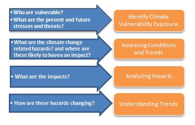
This module addresses the following sets of questions within the baseline components of the case study to begin an initial screening of the climate change risks to existing and future activities. These questions will help ensure that the selection, quality, accessibility and use of data and information are verified and improved as needed. Existing as well as potential sources of information necessary to answer these questions are listed throughout.
Technical Design
Step 1: Identify Climate Vulnerability Exposure
The purpose of this step is to identify:
- measurable climate variables that can be obtained from climate information systems (for the present) and archives of global climate change models (for relevant time periods in the future).
- gaps in knowledge where additional sectoral and livelihood studies are required (or may be available but not brought into the team’s expertise), at the local to national and even regional levels.
- climate variables and thresholds of concern that would be required in planning adaptation strategies and measures.
- factors that contribute to current vulnerability
Step 2: Assessing Conditions and Trends
Highlighting the location of specific hotspots in the country where climate-related hazards are experienced or likely to be felt is a key step in identifying intervention areas. The initial screening process begins with this question, which allows the user to reframe the climate change problem in the context of local conditions/constraints and opportunities. This can show whether climate change impacts are likely to be material for a particular development function, activity or service. The Moreover, Isolating these locations for further examination is a critical starting point. Further analysis of the trends and impacts of these hazards, when combined with key vulnerability indicators will help to narrow down priority zones for specific project targets.
- Spatial Dynamics
Translating indicators of vulnerability for specific exposure units/stresses (e.g populations at risk of drought) into vulnerability maps, and then defining hotpots and indicators of aggregate vulnerability using foundation datasets, which highlight the zones within the country that face exposure to specific hazards.
- Temporal Dynamics
Climatic variability poses significant repercussions for agricultural production, but its spatial and temporal manifestations are considerably varied. The issues before agricultural policy in the face of climate change are complex enough that misunderstanding the full ramifications of events such as temperature extremes, or for that matter, a trend through a specific period such as the 1990s, will have significant impact at the farm level. Disease, pests, droughts and large storms, these are issues of great importance to agriculture and they appear to vary both in space and in time. Understanding local patterns in the context of the immediate region will help guide the development of viable coping mechanisms, from agronomic practices to crop insurance, in the face of uncertainty regarding both the direction of climate change trends and its magnitude.
The diagnostic capacity to investigate these impacts can be significantly increased by coupling detailed historical meteorological data with innovative analytic methods. On the basis of available data and information, it is possible to analyze the conditions and trends in climate parameters, from the most basic data (e.g. maximum and minimum temperature and rainfall), to more elaborate indicators (duration of the growing season), to complex indices (satisfaction index of water requirements for the growing season) to allow the identification of important thresholds and trigger points on short and medium time scales. This information can be used to assess potentially impacts and identify anticipatory adaptation measures.
Step 4: Analyzing the Impacts of Climate Change
Climate related stresses can cause major adverse impacts on several sectors, including food production and agriculture, human health, and water availability, quality and accessibility, among others.
The purpose of addressing these questions is to assess and summarize the impacts of climate-related hazards on a specific region, country or sector. This step can provide the basis for defining both the measurable outputs and the implementation issues, particularly with respect to monitoring and evaluation in project activities. It also provides an opportunity for the risk assessment team to pay particular attention to sectoral studies at both regional and national levels, where data and information can be found concerning the critical climate values relevant to these sectors (e.g. rainfall values at which point agriculture becomes unfeasible).
The purpose of this step is to assess the range of future conditions. This step provides a link between the current vulnerability (hazards experienced so far), trends in hazards and the need for urgent action. If the trends observed above are consistent with the range of scenarios for future climate change, then the rationale for urgent action is much stronger.
The aim of the section is to answer questions such as:
- How will the risk of hazards change?
- Will identified thresholds be exceeded? How often, how widespread and where? How will that change the vulnerability of communities?
Supporting Documents
An overview of activities using AWhere (with examples for Afghanistan and the Horn of Africa)
Technical Support to Facilitate Step 2 of the NAPA Process
Worked examples
Adding locational specificity to the Tanzania NAPA document
Nepal vulnerability assessment
Rice production in Bali (see Vulnerability Assessment II)
(0) Comments
There is no content