Glacial Lake Outburst Flooding in Bhutan
Introduction
“The Land of the Thunder Dragon”, “The Last Shangrila” and the “Land of the Peaceful Dragon” all refer to the tiny kingdom of Bhutan nestled in the eastern part of the Great Himalayan Range. Located between the two giants of China in the north and India on the remaining three sides, Bhutan is populated with just over 780,000 people. The terrain is mostly rugged and mountainous with altitude ranging from less than 100m in the south to more than 7,500m in the north within a north-south distance of less than 175km. 20% of the land area is above 4,200m and permanently covered with snow and ice, which form glaciers and glacial lakes.
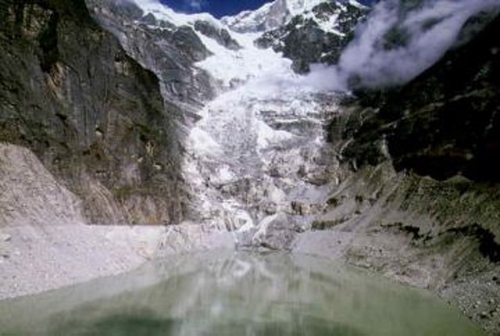
A major proportion of Bhutan’s population is settled in fertile valleys along a number of river systems. When a Glacial Lake Outburst Flood (GLOF) occurs along rivers which are sourced from glaciers and glacial lakes the lives and property of many people are at risk. Such devastating effects can still be seen today from the last GLOF that took place in Bhutan in 1994 along the Puna Tsang Chu valley. Not only are lives and property endangered but also important infrastructure such as hydroelectric dams that are situated along these rivers. If Gross National Happiness is the pride of the Bhutanese people then the driving force behind it is the hydroelectric power stations, which are driving the Bhutanese economy forwards with a contribution of about 45% to national revenue and 12% to GDP growth (ADB Review 2005).
The Government of Bhutan has taken a step towards adapting to climate change by developing a National Adaptation Program of Action (NAPA), coordinated by the National Environment Commission (NEC). The main objective of the NAPA has been to identify and address the most prominent issues related to climate change. Three projects from the Bhutan Department of Geology and Mines have been prioritized during the NAPA formulation. These are: artificial lowering of lake water level in the Thorthormi lakes; installation of early warning systems in Punakha-Wangdi valley; and hazard zonation mapping in Chamkhar.
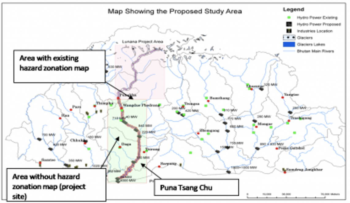
The Netherlands Climate Assistance Program (NCAP) supported a GLOF hazard zonation mapping exercise along the Puna Tsang Chu from Khuruthang to Lhamoizingkha. This project was not listed under the NAPA projects but was nevertheless considered important because: i) a hazard zonation map already exists from Lunana (source) to Khuruthang in Punakha, which was completed as part of an earlier Austria-Bhutan project; ii) a number of planned large hydroelectric power schemes are situated on the Puna Tsang Chu; and iii) earlier studies with Austrian and Japanese researchers demonstrated that lakes in Lunana still pose GLOF threats and recommended that hazard zonation mapping be carried out in this area.
Project Site
The project area lies in western Bhutan starting from Khuruthang in Puna Dzongkhag to Lhamoizingkha in southern Bhutan on the Bhutan-India border under Dagana Dzongkhag covering a distance of approximately 180km with an altitudinal variation of 1,800m in Punakha to less than 100m in Lhamoizingkha. The area covered in our project includes part of Punakha, Wangduephodrang, Tsirang and Dagana Dzongkhag.
Objectives
During the joint project between the Department of Geology and Mines with the experts from the University of Vienna, Austria, a hazard zonation map was prepared from the source of the Pho Chu to Khuruthang in Punakha. But the remaining area between Khuruthang and Lhamoizingkha remained an area without a hazard zonation map for Glacial Lake Outburst Flood (GLOF). A need for similar maps for the remaining area was realized considering the following reasons:
- The presence of critically dangerous glacial lakes at the source of the Pho Chu;
- The large number of settlements along the fertile valley bottoms along the Puna Tsang Chu;
- Large hydropower plants which both exist and which are in the pipeline on the Puna Tsang Chu; and
- Other developmental infrastructure along this river valley.
Therefore the main aim and objective of the DGM-NCAP project is to prepare a hazard zonation map from Khuruthang in Punakha to Lhamoizingkha on the Bhutan-India border under Dagana Dzonkhag, thus covering the entire area along the Puna Tsang Chu with a hazard map for GLOFs in the future. These maps are expected to serve as a tool to guide the planners and decision makers:
- As a tool for any future developmental activities along this river; and
- As a guide for the local communities and local authorities to minimize the damage on the lives and properties of the people.
This project was carried out under the Netherlands Climate Assistance Programme (NCAP)] which was funded by the Netherlands Ministry of Foreign Affairs. ETC International managed the overall NCAP project.
(0) Comments
There is no content