Climate Vulnerability Assessment for the Indian Himalayan Region using a common framework
Introduction
In-depth understanding of key vulnerabilities is essential for evidence based adaptation planning towards the risks of climate change impacts.
The Indian Himalayan Region (IHR) is highly vulnerable to climate change due to its fragile ecosystem and high dependence of communities on natural resources. Climate change poses unprecedented challenges for multiple sectors and socio-economic development in the region. A vulnerability assessment can help in generating understanding on the key vulnerabilities as well as their drivers. While some Indian Himalayan States have carried out vulnerability assessments within their states there has been no study done at regional level yet. Also, there has been no consistency in terms of the framework used for vulnerability assessments done within the states.
Understanding the need of an integrated approach towards adaptation, the Indian Himalayas Climate Adaptation Programme (IHCAP), supported the development of a common framework for climate vulnerability and risk assessment for IHR. The framework*, developed by the Indian Institute of Science, Bangalore with support from the Himalayan States, is based on the latest IPCC AR5 framework for risk assessment.
- Read more about the common framework on vulnerability assessment
- Read more about Applying the IPCC 2014 framework for hazard-specific vulnerability assessment under climate change
- Explore a geo-spatial climate vulnerability and risk information tool aimed at supporting states in developing adaptation programmes based on their climate change risk and vulnerabilities
*Download the framework and the results of the analysis of 12 Himalayan States from the right-hand column. A brief overview of this document is provided below.
Capacity Building through application of the Common Framework
The common framework for vulnerability and risk assessment was applied to understand the vulnerability profile of the entire Himalayan region with support from IIT Guwahati and IIT Mandi. The methodological framework was based on a common set of indicators, making them readily comparable for different areas. The aim was to develop state-level, and within states, district-level vulnerability maps and to identify potential drivers of vulnerability both at the state and district level in the 12 IHR states. This was done with participation of the State Climate Change Cells and other relevant line departments of all the Himalayan States as an initiative towards their capacity building to carry out such assessments.
A series of consultations and workshops with the representatives from the 12 IHR states was organised. It included three Need Assessment Workshops, one Methodology Workshop and a Dissemination Workshop. The purpose was not only to train them in the common methodological framework but also to brainstorm about the indicators of vulnerability, availability of data, challenges foreseen and ways to overcome these challenges. Such a coordinated approach and enhanced cooperation between states in the IHR and the departments within the state can contribute for improving the resilience to climate change as several adaptation interventions will require coordinated efforts across administrative boundaries. The assessment exercise is unique because for the first time all the 12 Himalayan states have used a common framework, resulting in the production of comparable maps.
Methodology for Vulnerability Assessment
The final set of common indicators and their weights were selected through discussion during the workshops. There are four broad categories of indicators used in the assessment based on those discussions:
- socio-economic, demographic status and health;
- sensitivity of agricultural production;
- forest dependent livelihoods; and
- access to information, services and infrastructure.
Each of these broad indicators has two to six sub-indicators for the state level analysis. The weights to be assigned to each indicator were decided through a consultative process. The average of the weights communicated by the states for each indicator was used to carry out the state-level vulnerability assessment. The weighted average of normalised values of the indicators was used to derive a composite vulnerability index and a vulnerability ranking of IHR states. Based on similar indicators district level vulnerability assessments were carried out by each of the states.
Results
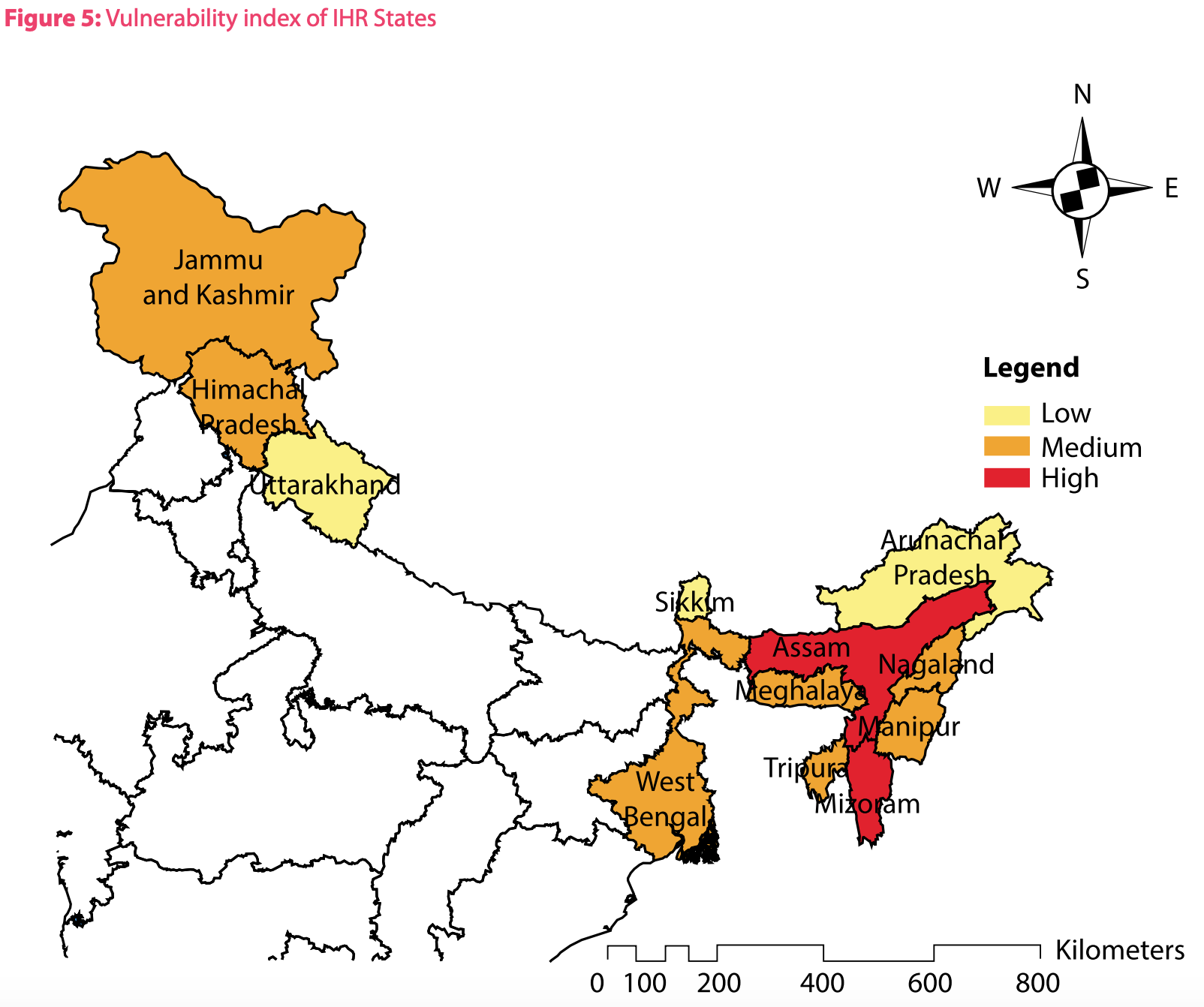
- Based on the composite vulnerability index values, the states have been ranked from highest vulnerability to lowest vulnerability. The vulnerability index is highest for Assam (0.72) and Mizoram (0.71), followed by Jammu & Kashmir (0.62), Manipur (0.59), Meghalaya and West Bengal (both 0.58), Nagaland (0.57), Himachal Pradesh and Tripura (0.51 both), Arunachal Pradesh (0.47) and Uttarakhand (0.45). Sikkim is the least vulnerable state with the index being 0.42. The values have been categorized as low, medium and high.
- It is important to note that all these states are vulnerable to climate risks and the fact that vulnerability is a relative measure implies that this assessment does not portray Sikkim, Uttarakhand or Arunachal Pradesh as having a low vulnerability in an absolute sense.
- The most important drivers of vulnerability identified by the states are low per capita income, lack of open forest area and less area of forest available per 1,000 households, lack of irrigation coverage, lack of availability of healthcare centres, high yield variability of food crops and higher proportion of marginal farmers.
Next Steps
The assessments carried out under IHCAP can be conceptualised as the beginning of a process and not the end.
- The vulnerability assessments conducted are primarily based on a macro level approach. In the future, it is envisaged that the states will carry out more in-depth assessments involving greater consultation with the stakeholders
- It will also be important to carry out sectoral vulnerability as appropriate for each of the states
- It is envisaged to assist the state climate change cells to upgrade/revise their State Action Plan for Climate Changes as per the state-of-the-art methodology
- It is planned to upscale this initiative and apply this common framework for a vulnerability assessment for all the states of India
Contribution to NMSHE
This initiative on ‘Climate Vulnerability and Risk Assessment’ has been supported by IHCAP, a project of the Swiss Agency for Development and Cooperation (SDC). IHCAP is being implemented as a bilateral cooperation programme with the Department of Science and Technology (DST), Government of India. IHCAP has been supporting the implementation of the National Mission for Sustaining the Himalayan Ecosystem (NMSHE) as a knowledge and technical partner. The development of the common framework and the capacity building initiative on vulnerability and risk assessment contributes towards the objectives of NMSHE and lays a foundation for a coordinated and integrated approach for adaptation in the Indian Himalayan Region. Though the framework has been presently applied to the Himalayan region it may be applied to the other regions of India as well.
(0) Comments
There is no content