Mapping the stories of climate change
Storytelling for climate adaptation using maps
The online platform Story Maps helps to better communicate climate change impacts and relevant adaptation measures in the Hindu Kush Himalaya to a wide audience, both to influence policy and for use at the community level. Robert Redford, the noted actor, philanthropist, and environmentalist, wrote a few years ago that the time is apt for the “pairing of scary statistics with inspiring stories”. For a layman, inspiring stories are preferable over statistics and numbers, whether scary or not. But what if a source existed that combined both, leading to immersive picture-driven narratives? This is the thinking behind Story Maps, a storytelling platform developed by ESRI, which is currently used widely as an effective mode of communicating a number of social and developmental issues. It allows users to choose from a variety of templates, to construct immersive storytelling that combines geospatial science and multimedia.
Story Maps and Climate Change in the Hindu Kush Himalaya
Why are Story Maps relevant in the context of climate change in the Hindu Kush Himalaya? As climate change unfolds in the region in real time, there continues to be a yawning gap in the knowledge of climate change of scientists and other practitioners, and of those affected by climate change.
Mapping stories of climate change not only contextualizes its effects by giving local examples, but also relates them to the relevant climate change data being produced. Funded by the International Development Research Centre (IDRC) and Department for International Development (DFID), the Himalayan Adaptation, Water and Resilience Research (HI-AWARE)consortia, working across the Hindu Kush Himalayan (HKH) region, is in the midst of capturing these narratives to better understand changing adaptation dynamics to climate change.
A Story Map can combine interactive content (maps, figures, videos) about a changing climate and its impacts on different sectors with short explanatory texts. The HI-AWARE story map interface depicts existing hazards such as precipitation, heat stress, droughts, and floods, with map data showing future projections of these hazards for the HKH region. Along with these projections, each section describes the sectors being affected, and some existing adaptation practices. It superimposes this information on a regional map. Users can navigate through the story, step-by-step, using their web browser.
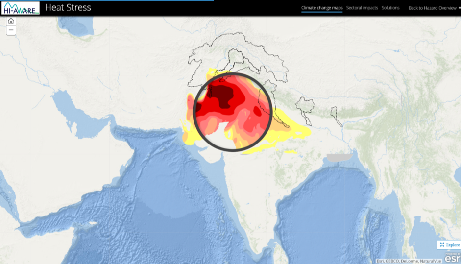
The site-specific narratives are essentially there to provide the story-telling element to these examples. Among the standard mapping tools is a ‘lens’ that shows how climate is likely to look in 2050 (see Figure 1 above). Users can explore potential climate impacts by moving the ‘climate lens’ to their area of interest. One can look inside the rounded lens for the climate in 2050, and outside the lens for how the climate is currently.
The importance of sharing stories
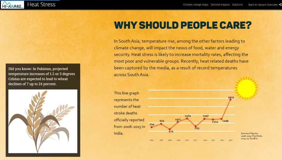
Relaying this information to a receptive audience, particularly those who will get affected, is essential. Although a lot of climate information is available nowadays, this knowledge often does not reach the wider public. Reports are seldom read and knowledge portals are often difficult to use. This is especially so in the case of climate change because it is a highly complex, long-term problem, often involving uncertainties at different levels. It also typically uses computer-modelled scenarios, which can be difficult for people to engage with. The key to successfully communicating messages lies in engaging with your public. Our ancestors knew how to do this, through the art of storytelling.
Through collaborative efforts and technical support from Climate Adaptation Services, Netherlands, this platform is meant to highlight new climate change insights and engage and invite users to share their experiences of climate change happening across the HKH region, and how they may have attempted to cope with them. For decision-makers, it provides a compact and action-oriented overview, which combines climate impacts with successful adaptation practices. By combining information about climate change impacts, with information about adaptation measures, the story map highlights the urgency of climate action to policymakers.

The Significance of Crowdsourcing
Why the emphasis on crowdsourcing? This is partly to ensure the longevity of the findings, as a means of it being carried forward for other users. Crowdsourcing helps overcome limitations such as logistical costs of visiting and mapping climate change issues that are currently not within the scope of the organization. More importantly, it encourages a discourse on open-source information sharing and discussion. Furthermore, in a region with a large and growing ICT sector, the platform is an appropriate example of piecing together evidence, and encouraging collaborative spaces. The current limitation of such a platform is that it is restricted to internet users. On the other hand, it allows access to a key, select audience, in that it becomes an effective demonstration tool for policymakers and decision-makers. And for those who are neither academics nor planners, this tool holds immense potential in its capacity to show adaptation measures at work in the region.
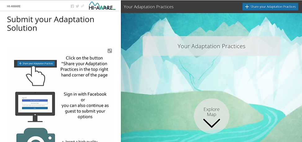
Another issue is the validity of the information involved – who would be the gatekeepers, and what parameters would be used to differentiate between good and average adaptation practices? For assessing this, a simple template has been devised, in which users can fill the required information needed in English to highlight their stories. They can submit photographs, their location, and a short description of their adaptation solution (Figure 4). This feature is still a work-in-progress, and is expected to improve with repeated interactions. A core committee that comprises of adaptation experts that are part of the HI-AWARE project, examine the submission. After it is vetted through the team the submission is circulated for review with all Co-Principal Investigators that are part of the HI-AWARE project. Only after they approval, does the work get published.
Looking forward
The concept of climate change, as a distant, long-term process, can be a challenge for the human brain to grasp. Story Maps provides an appealing new way to effectively tell the story of climate change by connecting compact scientific information to local anecdotes and bottom-up involvement in the Hindu Kush Himalayas. With the urgency needed for climate action, it provides a promising new option that deserves exploring. More importantly, this form of storytelling does not have a silent audience. Somewhere down the adaptation road, perhaps a community of practice can be put in place that uses such digital platforms for planning and decision-making.
Authors
This article was written by:
- Debabrat Sukla: Communication Officer at the International Centre for Integrated Mountain Development, Nepal
- Ishaan Kochhar: Consultant in Remote Sensing and GIS, at the International Centre for Integrated Mountain Development, Nepal
- Vishwas Sudhir Chitale: Remote Sensing Specialist in Ecosystems, at the International Centre for Integrated Mountain Development, Nepal
- Arjen Koekoek: Advisor and GIS specialist at Climate Adaptation Services, Netherlands
(0) Comments
There is no content