Participatory Geographic Information Systems (PGIS) for Urban Environmental Assessments
This tool is part of the SEI Urban Toolbox for Liveable Cities which has been developed by the SEI Initiative on City Health and Wellbeing. The Urban Toolbox is a collection of tools, developed within SEI or in coordination with SEI, aimed at supporting planning and decision-making for improving the health, well-being and resilience of city residents and urban systems more broadly.
About this tool
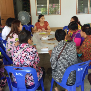
P-GIS is the practice of gathering data using traditional methods such as interviews, questions, focus groups, all using some form of paper maps to allow participants to record spatial details. This information is then digitised so that it can be analysed and interrogated using the power of the computer GIS software, and also so that any outputs can then be communicated using computer-drawn map outputs.
How does this tool work?
Using maps as discussion tools can allow different groups to share their knowledge of environmental issues and development options more clearly with the aim of incorporating this enhanced understanding to improve decision making and outcomes.
Who might use this tool?
City planners, community organisations, communities themselves
Which stakeholders are involved?
Any community (defined as a group with a common interest, shared knowledge or people living in a specific neighbourhood); urban planners; service providers (public and private sector)
What stage of the process does this tool support?
This tool can be adapted to be used at different stages of environmental assessment:
- defining the issue
- generating ideas
- developing solutions
- implementation
- monitoring
- evaluation
Tool overview
PGISprocesses involve various stages including: capturing local knowledge in a spatial (map) framework; transforming thisinformation into a digital format for storage, visualisation and analysis in a Geographic Information System (GIS); utilising the GIS tocompare and combine local stakeholder’s knowledge across a geographic extent andthematically with supplementary conventionally derived or official recognised datasets; toaddress questions and concerns raised by the communities involved in relation to thedevelopment of official policies, plansor strategies. PGIS relies on participation and builds upon concepts of empowerment which have long been recognised as taking different forms with varying legitimacy depending on the engagement process. Table 1 presents a typology of different goals and levels of empowerment for participants building from original framings, such as the ladder of citizen participation (Arnstein, 1969). The table highlights the different ways engagement between stakeholders and decision makers can play out and the consequent outcomes from participation. Ideally PGIS processes should enable ‘higher’ levels of participation (those on the right of the table) as opposed to simply informing or consulting.
Table 1: Spectrum of participation (International Association of Public Participation, 2007) (including elements from Arnstein’s “Ladder of Participation”(Arnstein, 1969)).
|
Increasing level of participation |
|||||
|
Inform |
Consult |
Involve |
Collaborate |
Empower |
|
|
Public participation goal |
To provide the public with balanced and objective information to assist them in understanding the problem, alternatives, opportunities and/ or solutions |
To obtain public feedback on analysis, alternatives and/or decisions |
To work directly with the public throughout the process to ensure that public concerns and aspirations are consistently understood and considered |
To partner with the public in each aspect of the decision including the development of alternatives and the identification of the preferred solution |
To place final decision-making in the hands of the public |
|
Promise to the public |
We will keep you informed |
We will keep you informed, listen to and acknowledge concerns and aspirations, and provide feedback on how public input influenced the decision |
We will work with you to ensure that your concerns and aspirations are directly reflected in the alternatives developed and provide feedback on how public input influenced the decision |
We will look to you for advice and innovation in formulating solutions and incorporate your advice and recommendations into the decisions to the maximum extent possible. We will implement what you decided |
We will implement what you decided |
Application: PGIS case study examples
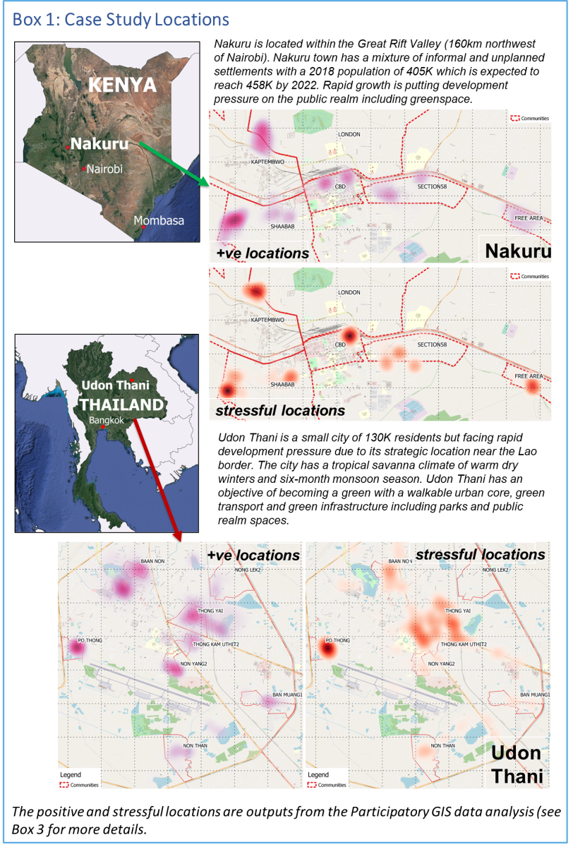
- Using PGIS to understand health and well-being in Udon Thani: this study used PGIS to explore interlinkages between access, availability and use ofurban public spaces and residents’ wellbeing in the rural city of Udon Thani, northern Thailand.
- Using PGIS to understand health and well-being in Nakuru: this study used PGIS to explore interlinkages between access, availability and use ofurban public spaces and residents’ wellbeing in the rural city of Nakuru, Kenya.
Capabilities and resources required
PGIS resources and capacities can be split into three groups:
- Participatory or Community Mapping – is the process of collecting community information on a map. This process requires:
- Suitable base maps (at a scale and resolution that enables participants to use them in discussions)
- Trained facilitators who can design and undertake the activity – these could be from the local community, NGO, academics or Local Authority
- Participatory GIS – this is the process of converting the paper maps into a digital format. This process requires:
- Access to a suitable GIS software (open source tools such as QGIS are freely available for this.
- Trained GIS operators who can convert the paper maps and undertake visualisations and analysis of the digital map data in the GIS
- Online PGIS Processes
- Web-based mapping approaches now allow PGIS activities to be undertaken online from the outset (without the need to digitize the data collected) (see for example Maptionnaire). This approach simplifies the data analysis but restricts who can participate to those with suitable computers, tablets and internet connectivity. This may limit participation and bias results.
Resources
Learning materials on PGIS
- P-GIS Tutorials by Steve Cinderby, Senior Researcher at SEI and University of York (2014).
- These tutorials, hosted in Prezi, provide a detailed guide for undertaking P-GIS processes, from gaining stakeholders’ consent to preparing GIS materials to recording data from P-GIS sessions to visualising and feeding back results.
- These tutorials contain links to additional learning and implementation resources.
- A Guide to using Community Mapping and Participatory-GIS by John Forrester and Steve Cinderby (2015).
Materials for PGIS implementation
- QGIS: A Free and Open Source Geographic Information System
- Maptionnaire community engagement platform
Complimentary materials
- Gender and GIS: Guidance Notes. These notes provide step-by-step guidance on integrating gender concerns in the production of GIS applications for environmental/natural resource management, disaster risk management and building resilience to climate change.
Related resources
- Participatory 3-Dimensional Modelling: Guiding Principles and Applications
- Participate! – an online course on how to better facilitate events on climate change adaptation and disaster risk reduction
- Background explainer: Participatory Processes
- How to reach the ‘hard-to-reach’: developing Participatory Geographic Information Systems for inclusive urban development
- Measuring health and wellbeing in rapidly growing cities
- A tale of two cities: inequalities in urban wellbeing in the Global South
(0) Comments
There is no content