Mountain observations: Monitoring, data, and information for science, policy, and society
Introduction
Observations play a key role in tracking mountain global change and its impacts, understanding the various processes and feedback mechanisms involved, and delivering more reliable projections of the future to society. This Policy Brief provides an overview of the current state of multi-disciplinary mountain observations.
It represents a contribution of the Global Network on Observations and Information in Mountain Environments (GEO Mountains) to the observance of the International Year of Sustainable Mountain Development 2022.
This weADAPT article is an abridged version of the original text, which can be downloaded from the right-hand column. Please access the original text for more detail, research purposes, full references, or to quote text.
Monitoring, Data and Information
The policy brief discusses different approaches and types of knowledge used to monitor and observe mountains:
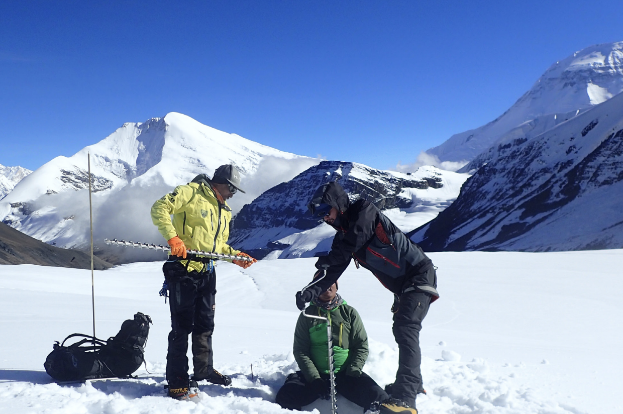
- In situ observations – in situ observations and measurements are crucial for tracking mountain climate and biodiversity change, downscaling and bias-correcting climate model outputs, calibrating remote sensing retrieval algorithms, and informing both process-based and data-driven climate impact models (e.g., cryospheric and hydrological models).
- Remote sensing – the quantity and quality of satellite remote sensing data available over mountainous terrain have risen dramatically over recent years and decades. Increasingly, to reduce the technical and computational burden on users, remotely sensed data are provided in pre-processed or even “analysis ready” formats.
- Gridded climate datasets, reanalyses, and models – (1) Gridded climate datasets are generated by interpolating in situ measurements using sophisticated techniques; (2) Climate reanalysis products are generated by running physics-based, coupled climate models into which in situ and remote sensing observations are continually fed; (3) Global Climate Models (GCMs) and Regional Climate Models (RCMs) provide future projections under various plausible greenhouse gas emission and land use change scenarios, in addition to historical reconstructions.
- Citizen science – Citizen Science (CS), whereby the public contribute to science by collecting or analysing data, has great potential to fill key spatio-temporal gaps in mountain observations and more generally increase the quantity of data available.
- Socio-economic data – Integrating socio-economic with bio-physical data has been widely recognised as necessary and important, however, has often proven difficult in practice. Many socio-economic datasets (e.g., census results) are provided in spatially aggregated formats.
- Regional, national, and thematic data portals – Given the geopolitically transboundary nature of many important mountain ranges, successful efforts have been made to collate and share mountain data and information on regional and national levels.
- Derived indicators – In contrast to scientists who often seek to obtain and use raw or lightly processed datasets, policy and other decision makers generally require derived and/or distilled information. Such information is commonly presented in the form of statistics, indices, or indicators.
- Indigenous knowledge – Indigenous communities have deep connections with their landscapes and extensive environmental knowledge. Novel approaches involving appropriate protocols and culturally sensitive knowledge co-production practices are now developed and applied to combine western and Indigenous knowledge forms.
Refer to pages 4-14 of the policy brief to explore each of these approaches in more detail.
Summary, Recommendations, and Outlook
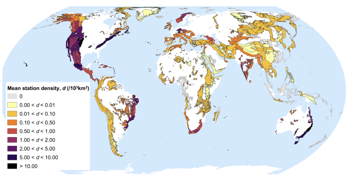
- Although mountain observation and monitoring remain challenging, a considerable amount of in situ monitoring infrastructure in place globally, and remotely sensed data volumes, are increasing rapidly.
- More extensive data coverage and information content analyses should be conducted as a basis for substantiating and optimising investments in establishing new, and maintaining existing, mountain monitoring initiatives.
- Optimal data coverage may not necessarily be uniform across all regions or disciplines.
- Investments and capacity sharing activities are required not only to install and maintain monitoring infrastructure, but to support the entire data lifecycle.
- To support more globally consistent and inter-comparable assessments of global change in mountain systems, observation campaigns should focus on agreed priority variables (“Essential or Shared Mountain Variables”).
- The entire mountain observation community should work towards increased standardisation and interoperability in terms of both variables observed and means of data sharing and access.
- Specifically, greater interdisciplinary collaboration between the biophysical sciences, the social sciences, and the humanities regarding data and data integration methodologies are required to improve our collective understanding and ability to predict future changes and their impacts in complex mountain social-ecological systems.
- Improvements in monitoring, data, and information – along with adequate funding and other resources to sustain, scale, and coordinate these efforts – will help close mountain knowledge gaps identified during the IPCC’s Sixth Assessment Reports.
- The integration of multiple datasets with the latest process-based models and machine learning algorithms, along with purposeful science-policy-practice dialogues and iterative exchanges to define relevant applications, have the potential to revolutionise the translation of mountain observations into knowledge and subsequent action.
Suggested Citation:
GEO Mountains (2022). Mountain Observations: Monitoring, Data, and Information for Science, Policy, and Society. Policy Brief: International Year of Sustainable Mountain Development 2022.
Related resources
- COP27 - Cascading impacts: how can we adapt and reduce risk in the mountains and downstream?
- A Global Community for Climate Change Adaption in Mountains
- Mountain Observatories: Status and Prospects for Enhancing and Connecting a Global Community
- Toward a definition of Essential Mountain Climate Variables
- Adaptation action and research in glaciated mountain systems: Are they enough to meet the challenge of climate change?
(1) Comment
My mountain dreams: Since my early childhood living in a mountain city of Iran called Arak I watched mountains and I loved mountains starting more than 65 years ago. Arak situated in the center of Iran with cold winters and so we were living about 6 months of the year with CORSI that is an Iranian wooden squer and fire under it. Later I started to climb some nearby mountains and continued up to now for about 60 years. Being an entomologist biologist later I started to study on mountain biodiversity, as a member of the MP I talked about it in the 4th global MP conference in Rome FAO December 2017.