Water Evaluation and Planning System (WEAP)
Description
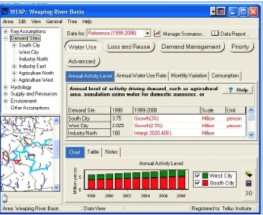
WEAP (“Water Evaluation And Planning” system) is a user-friendly software tool that takes an integrated approach to water resources planning.
Freshwater management challenges are increasingly common. Allocation of limited water resources between agricultural, municipal and environmental uses now requires the full integration of supply, demand, water quality and ecological considerations. The Water Evaluation and Planning system, or WEAP, aims to incorporate these issues into a practical yet robust tool for integrated water resources planning. WEAP was developed by the Stockholm Environment Institute’s Boston Center at the Tellus Institute. This SEI center is now independent of Tellus, and known as the Stockholm Environment Institute U.S. Center.
WEAP operates on the basic principle of a water balance and can be applied to municipal and agricultural systems, a single watershed or complex transboundary river basin systems. Moreover, WEAP can simulate a broad range of natural and engineered components of these systems, including rainfall runoff, baseflow, and groundwater recharge from precipitation; sectoral demand analyses; water conservation; water rights and allocation priorities, reservoir operations; hydropower generation; pollution tracking and water quality; vulnerability assessments; and ecosystem requirements. A financial analysis module also allows the user to investigate cost-benefit comparisons for projects.
WEAP has been used in several innovative ways to try and include human agency, decision-making and feedback within the model. See here for some examples.
Innovation: The Google Earth Adaptation Layer
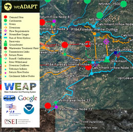
El Dorado WEAP work on the Adaptation Layer
Recent innovation has linked WEAP to Google Earth as part of a collaboration between the weADAPT Adaptation Layer and SEI water group, supported by Google.org. This is an exciting innovation that bridges the science, from climate envelopes to impacts, and policy, by visualising the system performance and potential responses.The prototype was demonstrated in meetings with the California state climate office, El Dorado Irrigation District (a northern California water utility) and Google.org in late April. The layer includes time series of snow melt in the water catchment (the Sierra Nevada), layers of climate and other impacts data (e.g. fire risk), WEAP output and nodes with supporting text, video, photos and charts. See here for more details on the data available.
Project Website:
Licensing:
License fee waived for academic, governmental and other non-profit organizations in developing countries.
Contact:
Export WEAP results to Google Earth
- Introduction and training resources for the WEAP Tool
- Building climate adaptation capacity in water resources planning
- Link to LEAP
- WEAP Summary of Mali Massabla case study
- More information on exporting WEAP results to Google Earth
- Tana WEAP-ABM
- Introducing Agency into Water Resource Simulation Models
- Using WEAP and Google Earth in California
(0) Comments
There is no content